
Crater Lake Ride
/Published Cycle California, September 2016, Vol. 22 #9
One of many Lake Tahoe circumnavigation rides is the self-proclaimed “America’s Most Beautiful Bike Ride” or AMBBR for short. Having done that ride, twice, I can say that the ride around Crater Lake, which I’ve done once, could also argue for that same title, or at least for America’s Most Beautiful Bike Ride around an Out West High Mountain Lake.
Crater Lake in southern Oregon is also the deepest lake in the county, officially 304 feet deeper than Tahoe, which is the second deepest. Officially, Tahoe’s official surface elevation is 6225 feet and Crater Lake’s is 6178 feet. Size-wise, Crater Lake can’t compare with that of Tahoe, about 1/10th of the larger lake spanning the California-Nevada border. Tahoe was first seen by white explorers in 1844 and Crater Lake in 1853, apparently a good decade for spotting lakes that the Native Americans had known about for thousands of years.
The Oregon ride I went on was called the Crater Lake Century. The pavement starting out of Fort Klamath was so rough, due to a recent heavy chip-sealing, myself and a few others bypassed the early mileage created as a flat maze for the glory of doing a full century.
Along with a group of Oregon bike buddies, we spent the pre-ride night in Klamath Falls, some 37 miles south of the starting point. No falls remain associated with the town but a Starbucks was there (alas no more as the market with a Starbucks counter closed in September 2015). By staying in town, we saved another hour’s drive over the mountains from our Ashland homes, extra time and sleep which helps for an early start on a cold morning.
The organized ride began at Fort Klamath. Like Klamath Falls, there’s no fort in Fort Klamath either. The infantry pulled out in 1890 and a home-like building now sits where the guardhouse once stood. We parked in a frosted, grass field and assembled for the pre-ride talk. Our race guide informed us that part of the road had been recently finely graveled ahead and also that the Crater Lake National Park authorities refused to have any upcoming potholes on the park roads painted, verbally adding “and some are huge so be careful,” an ominous foreboding for the our expected three hour time on park roads.
Foregoing the added mileage loop, our lead group headed out on Highway 62 the 20 miles to the park. Though it was August, the early morning was as cold as any summer ride at elevation that I’d ever begun, including the AMBBR in June and the Death Ride in July. At 5 miles, we hit the newly laid gravel, which surprising wasn’t that bad and for sure much better than those ragged grooves cut in before repaving work. The turn off Highway 62 towards park came after 2000 feet of elevation gain, which nullified the chill. It would be 500 feet more to park headquarters. The onerous climb was offset by spectacular views of the impressively deep Annie Creek Canyon on the right.
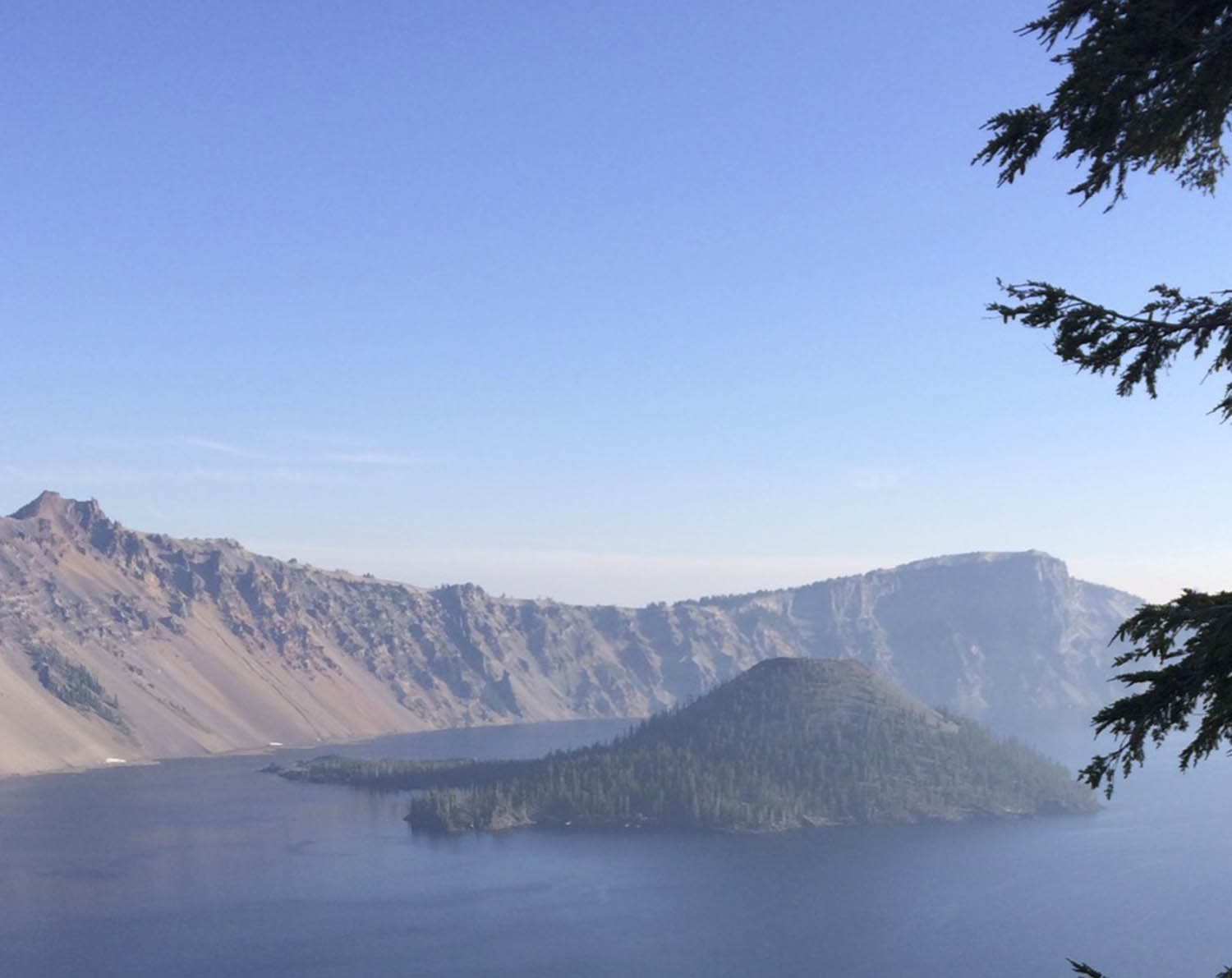
The road turned west, left, at the old-time Crater Lake Lodge and kept climbing, going clockwise with views to the western valleys and horizons far below. At 7000 feet, the road swung into a view of Wizard Island, the cone formed after Mt. Mazuma blew up an epoch ago, almost forming the massive gray-rock slopes forming the bowl opposite the island.
At 7700 feet and 7 miles around the lake, the road turned northeast, descending down and away from the lake, but later rejoining it and starting another 1000-foot climb. With the day now warmed up, I finally took off my windbreaker. Due to cutting out the first 20 miles of the century, I was well ahead of the main body of riders as well as the small cluster of early starters and so came solo upon a fork at 20 miles around the lake. To the right was newly oiled shiny pavement with an arrow directing our ride to take it. Ever so reluctant to do so but not knowing where it went, I took the fork and discovered that the surface was surprisingly not sticky. What I didn’t know but soon found out was that the road was a 1-mile out and back called Cloudgap Overlook, maxing out at just under 7900 feet elevation, the ride’s high point. The beauty of the overlook was offset, for me at least, by anxiety over the shiny slick topping, all for a simple loop. Getting back to the main road, I now wondered if my friends had bypassed the shiny-black-surface turn and gone on.
Ahead was Phantom Ship Overlook rest stop, which had a few riders already getting snacks. The phantom ship described the shape Wizard Island in the distance. Assuming my friends were behind but not knowing how far, I left the stop, once more heading away from the lake and inland. After 30 miles of eyes peeled, I finally found those unmarked potholes that came up too unannounced to readily avoid. Luckily, one dish, which was the whole width of the car lane, was actually so big and shallow that I sailed in and out without harm. The road continued through forest back to the scenic national park lodge, which I passed by, riding on.
Fearful of the gravel on the long descent back on Highway 62 to Fort Klamath, I carefully slalomed around the curves and did not have a problem. The ride ended with food prepared at the guardhouse, just another sunny afternoon in southern Oregon as my friends eventually arrived.
The AMBBR Lake Tahoe ride also adds an out-and-back to create a century option but the main loop around the lake is 72 miles long with over 4,024 vertical feet of climbing, which compares with the 4,471 feet of Crater Lake climbing in only 32 miles. Starting from Fort Klamath increases those totals to 78 miles with 7,441 feet of climbing. Both roads around Tahoe and Crater Lake start over 6,000 feet and ascend over 7,000 feet, adding a high altitude challenge as well. Ft. Klamath is 4,200 feet, which as a starting point allows you some breathing space to begin.
Tahoe has congested areas around Tahoe City and Kings Beach, but you do get dramatic scenes of the lake as well as the surrounding, often snow-capped peaks for almost all the ride. Crater Lake in Oregon’s Cascades is more remote and with none of the shoreline communities’ traffic issues of the Sierra’s lakeshore road. The Crater Lake roadway views outward of southern Oregon countryside from the topless mountainsides are magnificent while the view inward of the ancient crater-lined lake is serene and sublime. America’s Most Beautiful Bike Ride? Actually, Bicycling Magazine in 2012 ranked the Mt. Tam Century as California’s most beautiful ride, perhaps slighting Tahoe due to the road around splitting distance and views with Nevada. Meanwhile, the Crater Lake ride is listed as Oregon’s best, of course. One rider is quoted as saying, “If I had one last day on earth, I would ride the rim at Crater Lake.” For me, it’s a ride that I would love to repeat, maybe just to see if it’s just as spectacular counter-clockwise, no doubt.
